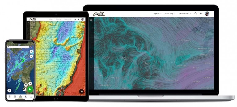
Pittsburgh, Penn. – ANGLR, the company creating innovative technology for the fishing industry, announced today new Premium Maps have been added to its popular mobile application. More than a dozen essential mapping tools are now available in three premium tiers: Elite, Freshwater and Saltwater.
For $48/year, Elite Map subscribers gain access to every available map for both freshwater and saltwater applications from environmental maps with weather and water conditions to charts, contours and other geospatial intelligence. For $36/year users can subscribe only to maps specific to either freshwater or saltwater applications. Premium Maps include: current doppler radar data; hourly global wind speed, gust, direction and 72-hour wind forecasts; 2D and 3D satellite imagery; severe weather forecasts including wind, thunder and tropical storm forecasts; National Weather Service precipitation forecasts and more.
“We are really excited to add the mapping tools our users have been asking us for,” said Nicholas Wilson, CEO, ANGLR. “ANGLR provides analytics and tracking information to help fishermen make better decisions. In the past, the content necessary for effective trip planning has been spread across multiple apps and services. With Premium Maps, passionate fishermen can now access all of this intel in one intuitive app with their waypoints, catches, photos, tackle and other fishing data right at their fingertips.”
With a free profile on the ANGLR app, anglers can plan, record and improve their fishing. Users can scout fishing locations and review key environmental conditions to effectively prepare for opportunistic fishing. The app easily marks catches, tackle usage and waypoints while automatically recording real-time GPS routes, weather and water conditions. With the resulting digital fishing log, anglers can quickly analyze trends and recognize patterns to improve their skills. Users can access maps from the comfort (and large screen) of a desktop or laptop computer using the map view feature, which syncs with the user’s profile for use on a mobile device in the field. The ‘fishing intelligence platform’ is crafted for anglers by anglers where every user’s data is private by default but can be shared (should they choose) among friends.
“ANGLR has become part of my routine on and off the water,” commented Gene Jensen, a popular Youtuber known as Flukemaster with nearly 300k subscribers comments. “It’s a no-brainer to have access to the details that define the difference between success and failure on the water. Premium Maps are yet another advantage to passionate anglers.”
The ANGLR app is available free from the Apple App Store or Google Play. The first 10,000 subscribers will receive three months of Premium Maps free. For more information visit www.anglr.com.
-30-
About ANGLR
ANGLR exists to empower fishing intelligence through measurement, learning and collaboration so that avid anglers can constantly improve and find more enjoyment in their sport. ANGLR is a platform built for anglers by anglers that consists of a free fishing logbook app which syncs across mobile and web devices, optional tracking accessories and a community of anglers who are passionate about growing and helping others. It provides private, powerful, personal fishing analytics always at your fingertips to help you plan, record and improve your fishing. www.ANGLR.com